V pátek 26. dubna 2024 úderem 22 hodiny začíná naše nová
a opravdu velká série soutěží o nejlepší webovou stránku !!
Proto neváhejte a začněte hned zítra soutěžit o lákavé ceny !!
a opravdu velká série soutěží o nejlepší webovou stránku !!
Proto neváhejte a začněte hned zítra soutěžit o lákavé ceny !!
Soubor:Westernsaharamap.png
Z Multimediaexpo.cz
Větší rozlišení není k dispozici.
Westernsaharamap.png (rozměr: 600 × 584 pixelů, velikost souboru: 256 kB, MIME typ: image/png)
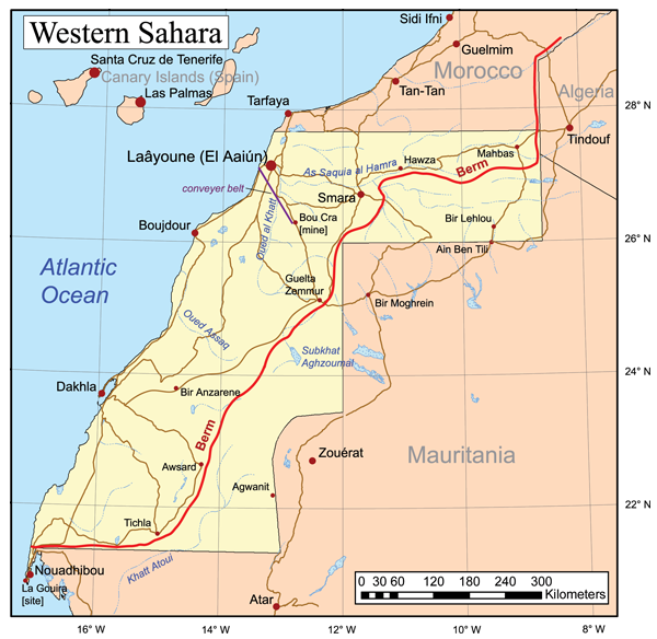
Mapa + Description: This is a general map of Western Sahara.
- The Polisario Front controls the area to the east of the berm, while Morocco controls the area to the west.
- Date: 2007
- Source: Own work based primarily on the Digital Chart of the World, with this UN map and commercial atlases (Rand McNally, Google, Encarta, and National Geographic) used as references.
- Author: Kmusser
+ pochází z Wikimedia Commons, kde má status – This file is licensed under the Creative Commons Attribution-Share Alike 2.5 Generic license. (CC BY-SA 2.5)
Historie souboru
Kliknutím na datum a čas se zobrazí tehdejší verze souboru.
| Datum a čas | Náhled | Rozměry | Uživatel | Komentář | |
|---|---|---|---|---|---|
| současná | 7. 10. 2019, 11:14 | | 600×584 (256 kB) | Sysop (diskuse | příspěvky) | (Mapa + Kategorie:Maps of Western Sahara) |
- Editovat tento soubor v externím programu (Více informací najdete v nápovědě pro nastavení.)
Odkazy na soubor
Na soubor odkazuje tato stránka:


