Soubor:Map-Germany-1947c.png
Z Multimediaexpo.cz
Velikost tohoto náhledu je: 706 × 600 pixelů
Obrázek ve vyšším rozlišení (rozměr: 2 000 × 1 699 pixelů, velikost souboru: 442 kB, MIME typ: image/png)
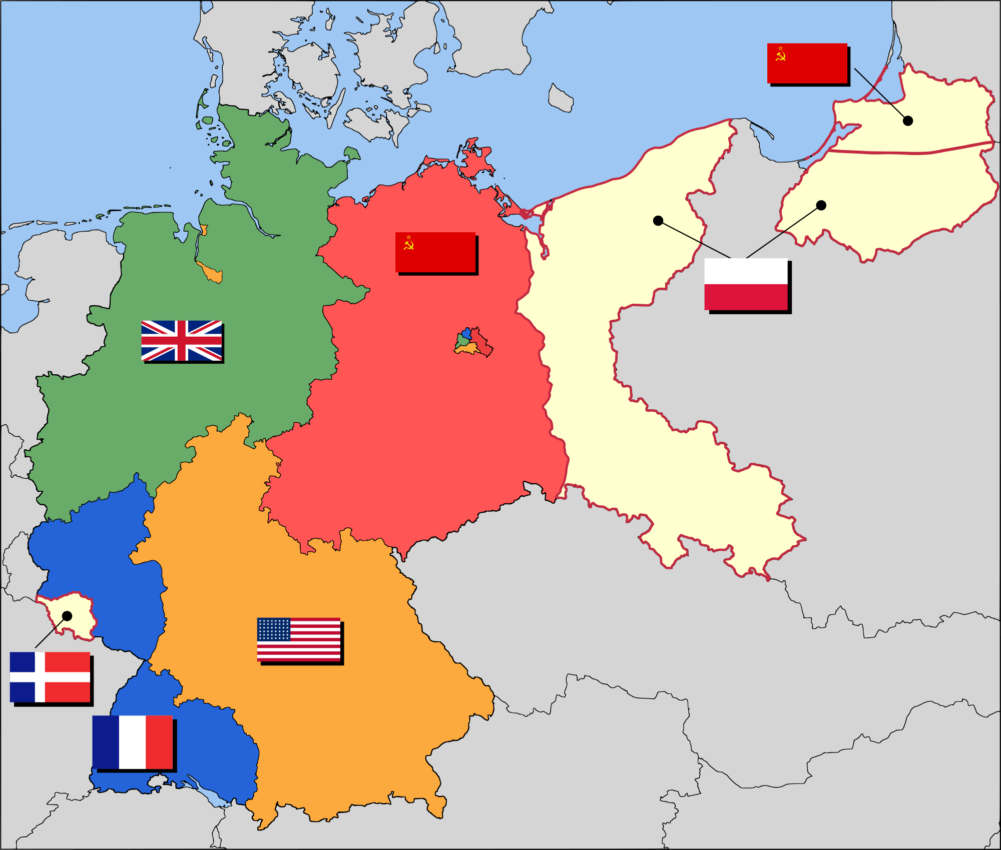
Mapa + English: Occupation zone borders in Germany, 1947. The territories east of the Oder-Neisse line, under Polish and Soviet administration/annexation, are shown as white as is the likewise detached Saar protectorate. Berlin is the multinational area within the Soviet zone.
- Deutsch: Grenzen der Besatzungszonen in Deutschland um 1947. Die Gebiete östlich von der Oder-Neiße-Grenze sind unter polnischer bzw. sowjetischer Verwaltung und sind weiß dargestellt, wie das Saar Protektorat. Berlin ist das multinationale Gebiet in der sowjetischen Zone.
- Čeština: Okupační zóny v Německu v roce 1947. Území na východ od linie Odra-Nisa anektované Polskem je zobrazené bílou barvou podobně jako protektorát Sársko. Berlín je několikanárodní oblast uvnitř sovětské zóny.
- Date: 10 August 2007
- Source: Based on map data of the IEG-Maps project (Andreas Kunz, B. Johnen and Joachim Robert Moeschl: University of Mainz, www.ieg-maps.uni-mainz.de).
- Author: 52 Pickup
+ pochází z Wikimedia Commons, kde má status – Creative Commons Attribution-Share Alike 2.5 Generic license.
Historie souboru
Kliknutím na datum a čas se zobrazí tehdejší verze souboru.
| Datum a čas | Náhled | Rozměry | Uživatel | Komentář | |
|---|---|---|---|---|---|
| současná | 20. 3. 2014, 14:52 | | 2 000×1 699 (442 kB) | Student85 (diskuse | příspěvky) | (MW115FOTO) |
- Editovat tento soubor v externím programu (Více informací najdete v nápovědě pro nastavení.)
Odkazy na soubor
Na soubor odkazují tyto 4 stránky:


