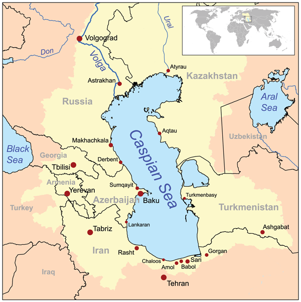
Soubor:Caspianseamap.png
Z Multimediaexpo.cz
Velikost tohoto náhledu je: 598 × 600 pixelů
Obrázek ve vyšším rozlišení (rozměr: 600 × 602 pixelů, velikost souboru: 199 kB, MIME typ: image/png)
Mapa + Description: This is a map of the Caspian Sea including a small locator map. The drainage basin of the Caspian Sea is in yellow. The map is based on USGS and Digital Chart of the World data. Note the Aral Sea boundaries are circa 1960, not current boundaries.
- Date: 8 January 2007 (original upload date)
- Author: No machine-readable author provided. Kmusser assumed (based on copyright claims).
+ pochází z Wikimedia Commons, kde má status – Creative Commons Attribution-Share Alike 2.5 Generic license.
Historie souboru
Kliknutím na datum a čas se zobrazí tehdejší verze souboru.
| Datum a čas | Náhled | Rozměry | Uživatel | Komentář | |
|---|---|---|---|---|---|
| současná | 25. 10. 2015, 20:35 | | 600×602 (199 kB) | Sysop (diskuse | příspěvky) | (Mapa + Description: This is a map of the Caspian Sea including a small locator map. The drainage basin of the Caspian Sea is in yellow. The map is based on USGS and Digital Chart of the World data. Note the Aral Sea boundaries are circa 1960, not current ) |
- Editovat tento soubor v externím programu (Více informací najdete v nápovědě pro nastavení.)
Odkazy na soubor
Na soubor odkazuje tato stránka:


