Soubor:Anguilla map.png
Z Multimediaexpo.cz
Větší rozlišení není k dispozici.
Anguilla_map.png (rozměr: 328 × 352 pixelů, velikost souboru: 15 kB, MIME typ: image/png)
Mapa + Description: Español: Mapa de Anguila
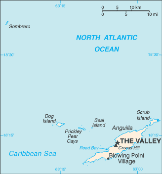
- English: Map of British overseas territory of Anguilla, comprising main eponymous island and smaller islets and cays.
- Date: Unknown date
- Source: CIA World Factbook
- Author: United States Central Intelligence Agency
+ pochází z Wikimedia Commons, kde má status – This image is a work of a Central Intelligence Agency employee, taken or made as part of that person's official duties. As a Work of the United States Government, this image or media is in the public domain in the United States.
Historie souboru
Kliknutím na datum a čas se zobrazí tehdejší verze souboru.
| Datum a čas | Náhled | Rozměry | Uživatel | Komentář | |
|---|---|---|---|---|---|
| současná | 10. 10. 2018, 18:41 | | 328×352 (15 kB) | Sysop (diskuse | příspěvky) | (Fotografie + ) |
- Editovat tento soubor v externím programu (Více informací najdete v nápovědě pro nastavení.)
Odkazy na soubor
Na soubor odkazují tyto 2 stránky:


